Nauta Routes

GALAPAGOS INFO

 The Galapagos Islands Have Been Declared
  • Natural Heritage of Humanity
  • Worldwide Biosphere Reserve
  • World Marine Resources Reserve
  • Whales Sanctuary
  • World Top Dive Destination
  • One of the Seven Underwater Wonders of the World
  • World Shark Mecca (Darwin & Wolf Islands)

ORIGIN

 
The tectonic movements were the main responsible for the creation of the Galapagos Islands about 4 or 5 million years ago. When a tectonic plate moves into an area of the Earth’s mantle that is especially hot, it forms what is called a hot spot. These areas are usually relatively seasonal and, for this reason, they cause a large amount of magma to rise, which ends up perforating the tectonic plate.
 
This is what happened with the Galapagos. After the magma rose, deposits of molten rock were formed that eventually became a solid surface. Cordilleras of volcanic matter formed until they became the surface of the islands. It is estimated that the Galapagos hot spot has a diameter of up to 150 kilometers and is located in its westernmost part. All the islands are located north of the Nazca plate, which moves about five centimeters to the east and southeast each year. Despite this displacement, the hot spot does not change location.
 
However, various formations continue to emerge that move away from this point and allow the creation of a greater number of volcanoes and islands. For this reason, it can be deduced that all those that are farthest from the hot spot are the oldest. On the other hand, the closest ones are those that have been formed most recently. For example, the formation process of San Cristóbal began more than 4 million years ago. For its part, the island of Fernandina has less than 700,000; it has one of the most active volcanoes in the world.


Something curious happens with the Nazca plate. As it moves east, it collides with the South American plate. This is continental type, while the Nazca is oceanic, which causes it to sink below the other. When this phenomenon occurs, the plate enters the interior of the mantle, begins to melt and reaches the surface. This process culminates in the formation of a volcano. The Nazca plate itself borders the Cocos plate to the north, the Pacific plate to the west, and the Antarctic plate to the south.
 
Two types of volcanoes can be found in the archipelago. On the one hand, the so-called shield volcano. It has little slope and its lava is very viscous, that is, it has a much more liquid appearance. On the other hand, what is known as a compound cone volcano. In this case, it has different layers of lava, as well as ash.


The origin of Galapagos gave way to the process in which the different islands were formed. Generally speaking, only one volcano was required to complete the formation process of each of the islands. The only exception was the island of Isabela, which needed many more volcanoes.
 
The volcanoes initially formed islands of rocks and lava. In addition, the colossi expelled water vapor that, being in interaction with the atmosphere, caused rain and humidity. After a few million years, the lava began to erode due to rain and atmospheric conditions and formed soils. The wind and sea currents carried mosses, ferns, seeds and also insects to Galapagos. Then the first birds arrived. Other animals such as turtles or iguanas reached the islands through sea currents.
 
Two types of volcanoes can be found in the archipelago. On the one hand, the so-called shield volcano. It has little slope and its lava is very viscous, that is, it has a much more liquid appearance. On the other hand, what is known as a compound cone volcano. In this case, it has different layers of lava, as well as ash.
 
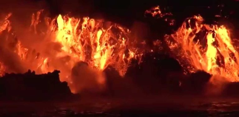
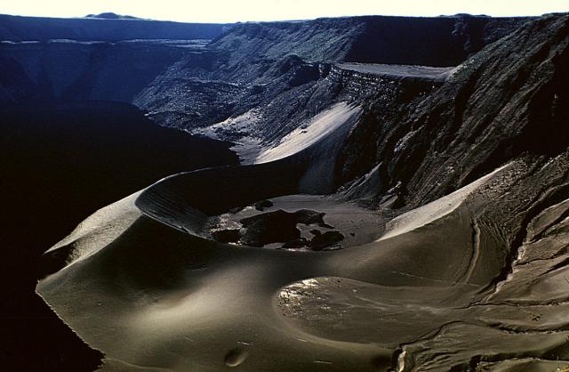
In the last two centuries, the Galapagos have experienced multiple eruptions. This indicates that the volcanoes are still active and, consequently, new islands are being formed. The last eruption occurred on Fernandina Island in January 2020. For this reason, it is common to see plumes of steam on both Isabela Island and Fernandina Island. One of the main materials that was responsible for the creation of the different islands is basalt, a type of rock created from basaltic lava. This class of material is one of the most liquid and comes, in most cases, from the so-called oceanic crust. This allows him to reach farther and create shield volcanoes.
 
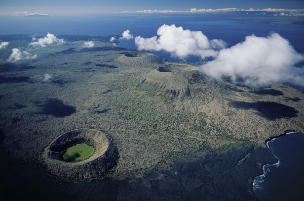
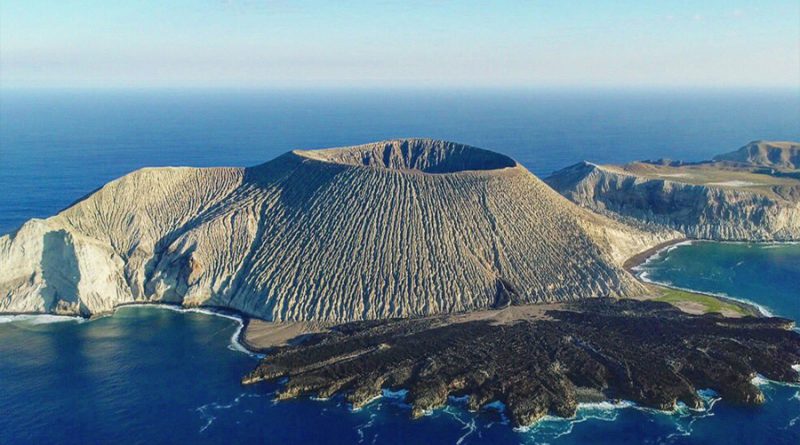
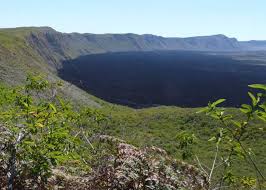
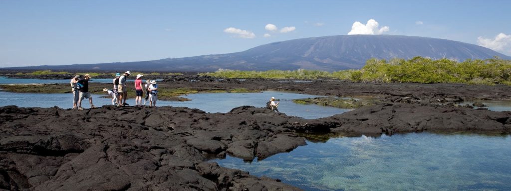
At the top of many of the Galapagos volcanoes you can find a caldera. It is in this depression that the crater of the volcano itself was initially formed. No lava was ejected towards the center of the volcano, it moved away from the hot spot and created the current huge cavity inside. On Isabela Island you can see the largest caldera -Sierra Negra-, which measures 9.3 x 7.4 kilometers.


Who discovered the Galapagos Islands?

Fray Tomás de Berlanga is the first known person to accidentally find the islands on March 10, 1535. On a voyage from Panama to Peru. Being the only person at the time in a position to report his evidence to the Spanish rulers, he is now credited as the official “discoverer” of the Galapagos Islands.


De Berlanga was born in Soria, Spain. He was the fourth bishop of Panama.
 
He stumbled upon the islands purely by chance during a sailing trip. This encounter with the islands was not really a happy one. Unexpectedly strong currents caused their ship to veer off course towards the islands.
 
At that point, his expedition crew ran out of fresh water, which could not be found on any of the islands they encountered. In fact, they actually had to resort to squeezing water out of prickly cacti to survive. Several members of his crew did not make it…
who discovered the galapagos islands
 Were the Galapagos visited by the Incas before the Spanish?
 
Some historians have claimed that the Inca king Tupac Yupanqui visited the islands at least 6 decades before Fray De Berlanga. But this is supported only by oral accounts (which many people believe to be made up).
 
Most experts say that it is more likely that the Incas discovered Easter Island. A study by Norwegian explorer Thor Heyerdahl and Skjolsvold in 1953 revealed that possible Inca pottery was found before the arrival of the Spanish in the Galapagos Islands, but tombs or constructions have never been found. After discovering what appeared to be pre-Columbian pottery remains and many other artifacts on the Galapagos Islands (which could even indicate a period of settlement).
 
The evidence is still considered inconclusive and doubts remain, especially since the Incas were not known as a seafaring culture.
When did the Galapagos Islands first appear on the map?
 
The first known maps date from 1570 where they are called “The Turtle Islands”. The map it was found on was the Theatrum Orbis Terrarum, which was prepared by a Flemish cartographer known as Abraham Ortelius. These maps weren’t really accurate, but at least they gave the explorers an idea of what to expect.


Interesting facts about Galapagos
 
The archipelago was used as a hideout for English pirates who docked Spanish and other galleons until the early 19th century, hence the English names of the islands. Although today the official names used in Spanish are widely used
 
          The navigator James Colnett described the place in his books as islands rich in flora and fauna. From 1798 this attracted early settlers (mostly English) with an interest in whales, sperm whales, sea lions and turtles.
 
        The discovery of sperm whale blubber also attracted many whalers which later even led to the creation of a makeshift post office, from where ships left and letters were collected.


Time after its independence and 3 years before the famous voyage of Darwin’s Beagle, Ecuador annexed them to its territory exactly on February 12, 1832, under the government of General Juan José Flores. Baptizing them as “Archipiélago de Colón”

 
  Approximately one hundred years later, the Galapagos Islands were inhabited by only a few settlers and were used as penal colonies. (Although this only came out until 1959 when the last one was officially closed)
 
           97% of the land surface is National Park and covers approximately 7,970 km2
           The natural beauty of the islands, the diversity and uniqueness of the species it houses, its volcanic origin, its geological dynamics with permanent changes and variety of formations. Being considered a living laboratory of evolutionary processes still in progress, added to the fact that it allowed the development of a large number of animal and plant species that do not exist anywhere else in the world, makes Galapagos a very unique place with a global reach. . Importance for the common heritage of humanity.
          In Galapagos, only 5 islands have some type of human settlement: Santa Cruz, is the most central island of the archipelago; This proximity to the rest of the populated islands is what has favored its productive, commercial and transport development.
          San Cristóbal is the capital of the island province and concentrates most of the government agencies.
          Isabela is the largest island and one of the most diverse. Its population is relatively small but ecotourism with local participation has been greatly developed in recent years.
          Floreana, despite being the first inhabited island in the Galapagos, has a small population that does not exceed 120 inhabitants.
          And Baltra, an arid island that received a US air base during World War II where it is now the main airport and with only stable military inhabitants.
          To improve the management of protected areas, the Directorate of the Galapagos National Park introduced zoning for land use planning. This dynamic and adaptive process is an effective planning and management tool, dividing the national park according to its conservation and its ability to support certain human activities.
          In this way, the 330 islands, islets and cliffs have been divided into: Absolute Protection Zone, which refers to virgin or almost virgin areas, free of known impacts of human origin; Ecosystem Conservation and Restoration Zone, are areas that show a certain degree of deterioration with the presence or absence of introduced organisms or human impacts. Impact Reduction Zone, which constitutes the peripheral areas of the national park with a significant degree of deterioration, located in areas adjacent to urban or agricultural areas.
          The endemic and native flora and fauna, unique in the world, make the Galapagos Islands an exceptional place. The most representative species of the Galapagos National Park are the giant tortoises, which give the archipelago its name. Initially there were 14 species of turtles, but the human predation of which they were victims in the 18th century by pirates and whalers, leading to the extinction of 3 species, and the constant eruptions of the La Cumbre volcano in Fernandina also killed off the species. Of this island, naturally.
          The most recent extinction that caused worldwide consternation was that of the emblematic Lonesome George, the only specimen of the species Chelonoidis abingdonii, from Pinta Island, who died of natural causes inside his corral, at the Santa Cruz Island Giant Tortoise Breeding Center. , after 40 years of captivity. We also have among the main attractions that can be admired on land: petrels, pelicans, frigatebirds, 18 types of finches, night herons, lava herons, white heron, royal lapwing, oystercatchers, mockingbirds, witch bird, lava gulls, seagull forked tail, tern, ducks, masked boobies, blue footed boobies, red footed boobies; chickens, cormorants, ticks, swallows, puffins, tropical birds, albatrosses, terns, flamingos, sparrow hawks, owls, evening bat, Zayapas, endemic mouse.
 
Galapagos Marine Reserve
 
          It has an area of 133 thousand square kilometers, which makes it one of the 10 largest in the world, which is also one of the best destinations in the world for underwater diving.
 
          The marine protected area includes the 40 miles from the baseline that make up the border islands of the archipelago (extreme coast), outwards, and also inland waters.
 
          This area is protected against illegal fishing and overexploitation of marine resources. Ecosystems cannot survive without the protection of marine and coastal environments. Many native and endemic species depend entirely on the sea and on the evolutionary and ecological processes that occur on land, but which have a direct relationship with the sea. More than 2900 species have been reported in the ecosystem of the Marine Reserve. which 25% of marine organisms are endemic.


Diving-shark
× WApp