The Galapagos Islands have been declared
– Natural Heritage of Humanity
– Worldwide Biosphere Reserve
– World Marine Resources Reserve
– Whales Sanctuary
– World Top Dive Destination
– One of the Seven Underwater Wonders of the World
– World Shark Mecca (Darwin & Wolf Islands)
ORIGIN OF THE GALAPAGOS
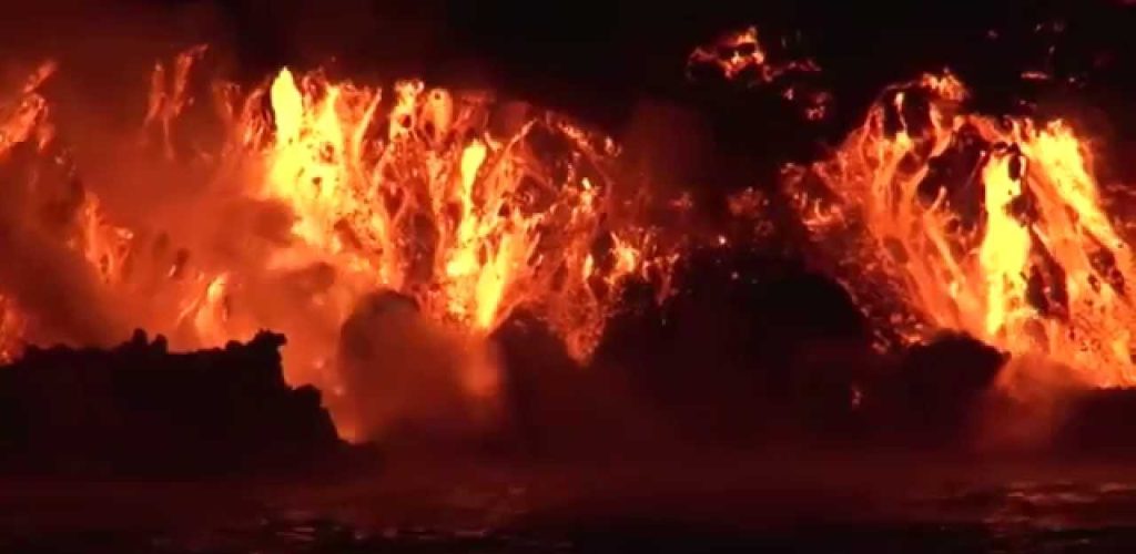
The tectonic movements were the main responsible for the creation of the Galapagos Islands about 4 or 5 million years ago. When a tectonic plate moves into an area of the Earth’s mantle that is especially hot, it forms what is called a hot spot. These areas are usually relatively seasonal and, for this reason, they cause a large amount of magma to rise, which ends up perforating the tectonic plate.
This is what happened with the Galapagos. After the magma rose, deposits of molten rock were formed that eventually became a solid surface. Cordilleras of volcanic matter formed until they became the surface of the islands. It is estimated that the Galapagos hot spot has a diameter of up to 150 kilometers and is located in its westernmost part. All the islands are located north of the Nazca plate, which moves about five centimeters to the east and southeast each year. Despite this displacement, the hot spot does not change location.
However, various formations continue to emerge that move away from this point and allow the creation of a greater number of volcanoes and islands. For this reason, it can be deduced that all those that are farthest from the hot spot are the oldest. On the other hand, the closest ones are those that have been formed most recently. For example, the formation process of San Cristóbal began more than 4 million years ago. For its part, the island of Fernandina has less than 700,000; it has one of the most active volcanoes in the world.
Something curious happens with the Nazca plate. As it moves east, it collides with the South American plate. This is continental type, while the Nazca is oceanic, which causes it to sink below the other. When this phenomenon occurs, the plate enters the interior of the mantle, begins to melt and reaches the surface. This process culminates in the formation of a volcano. The Nazca plate itself borders the Cocos plate to the north, the Pacific plate to the west, and the Antarctic plate to the south.
Two types of volcanoes can be found in the archipelago. On the one hand, the so-called shield volcano. It has little slope and its lava is very viscous, that is, it has a much more liquid appearance. On the other hand, what is known as a compound cone volcano. In this case, it has different layers of lava, as well as ash.
The origin of Galapagos gave way to the process in which the different islands were formed. Generally speaking, only one volcano was required to complete the formation process of each of the islands. The only exception was the island of Isabela, which needed many more volcanoes.
Los volcanes inicialmente formaron islas de rocas y lava. Además, los colosos expulsaban vapor de agua que, al estar en interacción con la atmósfera, provocaba lluvia y humedad. Después de unos pocos millones de años, la lava comenzó a erosionarse debido a la lluvia y las condiciones atmosféricas y formó suelos. El viento y las corrientes marinas llevaron musgos, helechos, semillas y también insectos a Galápagos. Entonces llegaron los primeros pájaros. Otros animales como tortugas o iguanas llegaron a las islas a través de las corrientes marinas.
Two types of volcanoes can be found in the archipelago. On the one hand, the so-called shield volcano. It has little slope and its lava is very viscous, that is, it has a much more liquid appearance. On the other hand, what is known as a compound cone volcano. In this case, it has different layers of lava, as well as ash.
In the last two centuries, the Galapagos have experienced multiple eruptions. This indicates that the volcanoes are still active and, consequently, new islands are being formed. The last eruption occurred on Fernandina Island in January 2020. For this reason, it is common to see plumes of steam on both Isabela Island and Fernandina Island. One of the main materials that was responsible for the creation of the different islands is basalt, a type of rock created from basaltic lava. This class of material is one of the most liquid and comes, in most cases, from the so-called oceanic crust. This allows him to reach farther and create shield volcanoes.
At the top of many of the Galapagos volcanoes you can find a caldera. It is in this depression that the crater of the volcano itself was initially formed. No lava was ejected towards the center of the volcano, it moved away from the hot spot and created the current huge cavity inside. On Isabela Island you can see the largest caldera -Sierra Negra-, which measures 9.3 x 7.4 kilometers.
Things to know about the Galapagos Islands
Who discovered the Galapagos Islands? And When?
Fray Tomás de Berlanga is the first known person to accidentally find the islands on March 10, 1535. On a voyage from Panama to Peru. Being the only person at the time in a position to report his findings to the Spanish rulers, he now he is credited as the official “discoverer” of the Galapagos Islands.
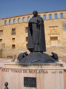
Who was Fray Tomás de Berlanga?
De Berlanga was born in Soria, Spain. He was the fourth Bishop of Panama.
He happened upon the islands by pure chance during a sailing voyage. This encounter with the islands wasn’t really a happy one. Unexpectedly strong currents caused his ship to drift off course towards the islands.
At the time, his expedition crew was running low on freshwater, which they failed to find on any of the islands they encountered. In fact, they actually had to resort to squeezing water out from prickly cactus pads to survive. Several members of his crew didn’t make it…
Were the Galapagos visited by the Incas before the Spaniards?
Some historians have claimed that the Inca king Tupac Yupanqui visited the islands at least 6 decades before Fray De Berlanga. But this is supported just by oral accounts (which many people believe to be fabricated). Most experts say that it is more likely that the Incas discovered Easter Island instead.
A study by Norwegian explorer Thor Heyerdahl and Skjolsvold in 1953 revealed that possible Inca pottery was found before the arrival of the Spaniards in the Galapagos Islands, but no graves or constructions have ever been found.
After discovering what seemed to be remains of pre-Colombian pottery and many other artifacts on the Galapagos Islands (which might point to even a period of settlement). The evidence is still seen as inconclusive and doubts remain, especially as the Incas were not known as a seafaring culture.
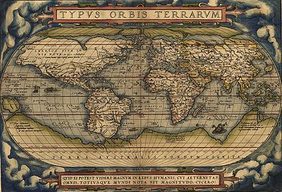
When did the Galapagos Islands first appear on the map?
The first maps that are known date back to 1570 where they are called “The Turtle Islands.”
The map they were found on was Theatrum Orbis Terrarum which was prepared by a Flemish cartographer known as Abraham Ortelius. These maps weren’t really accurate but at least gave explorers an idea of what to expect.
Interesting facts about the Galapagos
– The archipelago was used as a hiding place for English pirates who docked the Spanish Galleons and others until the early 1800s, hence the English names of the islands. Although nowadays the official names used in Spanish are used on a general basis.
The navigator James Colnett described in his books the place as islands rich in flora and fauna. From 1798 this attracted the first settlers, (mostly English) with interest in whales, sperm whales, sea lions, and turtles.
The discovery of sperm whale fat also attracted many whalers
which later even led to the creation of an improvised post office, where ships left and collected letters.
What Country do the Galapagos Islands belong to?
Shortly after its independence and 3 years before Darwin’s famous Beagle voyage, Ecuador annexed them to its territory exactly on February 12, 1832, under the government of General Juan José Flores. Baptizing them as “Archipelago de Colón”
For roughly a hundred years thereafter, the Galapagos Islands were inhabited only by a few settlers and were used as penal colonies. (Although, this only lasted until 1959 when the last one was officially closed)
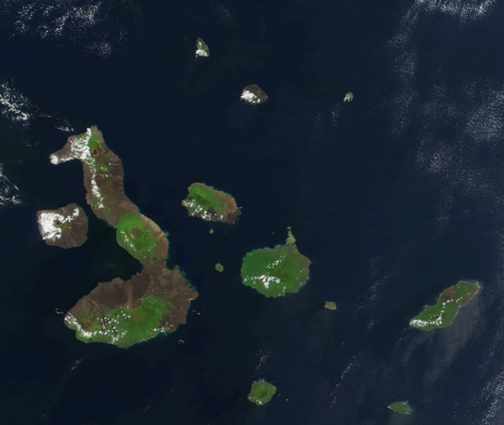
97% of the land area is National Park and covers approximately 7,970 km2
The natural beauty of the islands, the diversity and uniqueness of the species it hosts, its volcanic origin, its geological dynamics with permanent changes and variety of formations; Being considered a living laboratory of evolutionary processes still underway, added to the fact that it allowed for the development of a large number of both animal and plant species that do not exist anywhere else in the world, make Galapagos a very unique place and of global importance for the common heritage of humanity.
In Galapagos, only 5 islands have some kind of human settlement: Santa Cruz, is the most central island in the archipelago; This proximity to the other populated islands is what has favored its productive, commercial and transportation development.
San Cristóbal, is the capital of the island province and concentrates the majority of government agencies.
Isabela, is the largest island and one of the most diverse. Its population is relatively small but in recent years it has largely developed ecotourism with local participation.
Floreana, despite being the first inhabited island of Galapagos, has a small population that does not exceed 120 inhabitants.
And Baltra, an arid island that received an American air base during World War II where it is now the main airport and with only military-stable inhabitants.
To improve the management of protected areas, the Directorate of the Galapagos National Park introduced a zoning for land use planning. This dynamic and adaptive process is an effective planning and management tool, so that it divides the national park based on its conservation and its ability to support certain human activities.
In this way the 330 islands, islets and rocks have been divided into:
Absolute Protection Zone, which refers to pristine or almost pristine areas, free of known impacts of human origin;
Ecosystem Conservation and Restoration Zone, are areas that show a certain degree of alteration with the presence or absence of introduced organisms or human impacts.
Impact Reduction Zone, constitute the peripheral areas of the national park with a significant degree of alteration, located in areas adjacent to urban or agricultural areas.
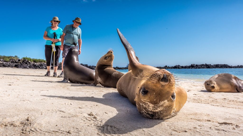
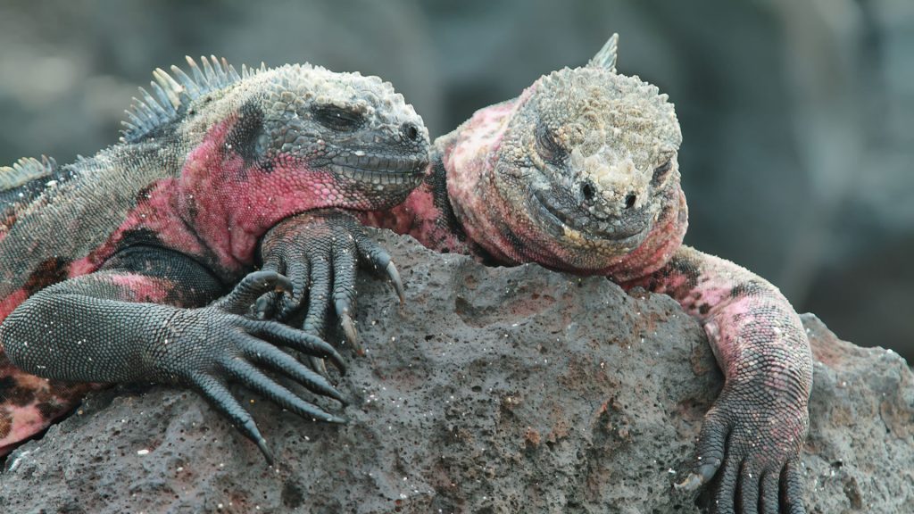
The endemic and native flora and fauna unique in the world, make the Galapagos Islands an exceptional place. The most representative species of the Galapagos National Park are the giant tortoises, which give their name to the archipelago. Initially there were 14 species of turtles, but the human predation of which they were victims in the eighteenth century by pirates and whalers, caused the extinction of 3 species, and the constant eruptions of the volcano La Cumbre, in Fernandina also ended the species of this island, naturally.
The most recent extinction that caused worldwide consternation was that of the emblematic Solitaire George, the only specimen of the Chelonoidis abingdonii species, from Pinta Island, who died from natural causes within his pen, at the Giant Turtle Breeding Center on the island Santa Cruz, after 40 years of captivity. We also have among the main attractions that can be admired on land: petreles, pelicanos, fragatas, 18 tipos de pinzones, garza nocturnas, garzas de lava, garza blanca, tero real, ostreros, cucuves, pájaro brujo, gaviotas de lava, gaviota de cola bifurcada, gaviotín, patillos, piqueros enmascarados, piqueros patas azules, piqueros patas rojas; gallinulas, cormoranes, garrapateros, golondrina, pufinos, ave tropical, albatros, golondrina de mar, flamingos, gavilanes, lechuzas, murciélago vespertino, Zayapas, ratón endémico, lagartijas de lava, iguanas de tierra, iguanas marinas, lobos marinos, lobos de dos pelos, pingüinos.
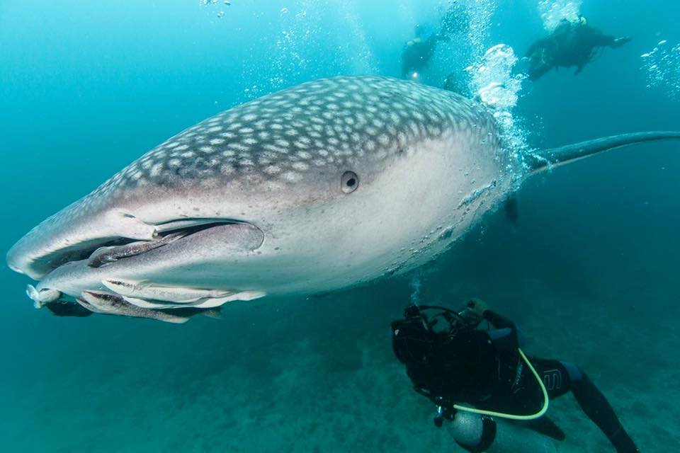
Galapagos Marine Reserve
It has an area of 133 thousand square kilometers, which makes it one of the 10 largest in the world, which is also one of the best destinations in the world for underwater diving.
The protected marine area comprises 40 miles from the baseline that make up the border islands of the archipelago (coastal end), outward, and also inland waters.
This area is protected against illegal fishing and over-exploitation of sea resources Ecosystems cannot survive without the protection of marine and coastal environments. Many native and endemic species depend entirely on the sea and on the evolutionary and ecological processes that occur on land, but which have a direct relationship with the sea. More than 2900 species have been reported in the Marine Reserve ecosystem. which 25% of marine organisms are endemic.